 |
 |
 |
|||||
|
|
|
|
|
|
|
|
|
|
|
|||||||
| |
|
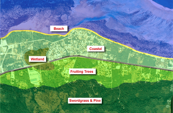
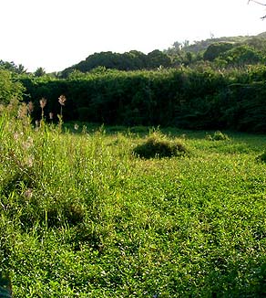
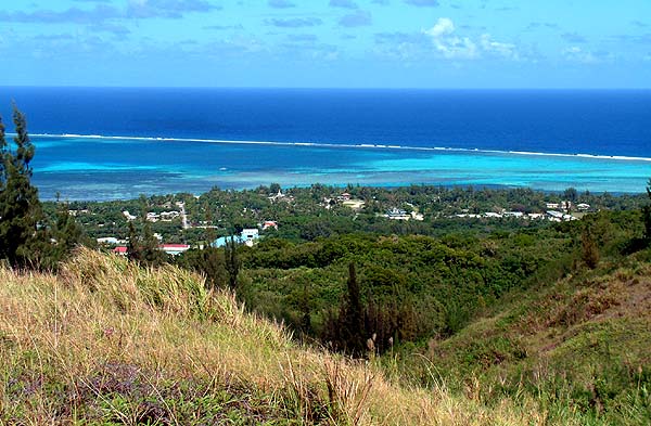
“We don’t really have so much elevation here that you have a lot of different environmental zones,” Ben says. “The highest elevation here on the island is 1500 feet from sea level.” Nonetheless, Ben is able to distinguish four different zones according to elevation and vegetation. The lowest elevation zone is wetlands.
|
||
|
|
||
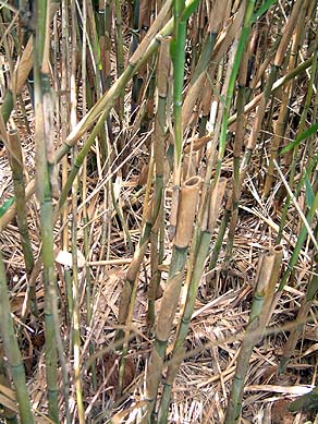
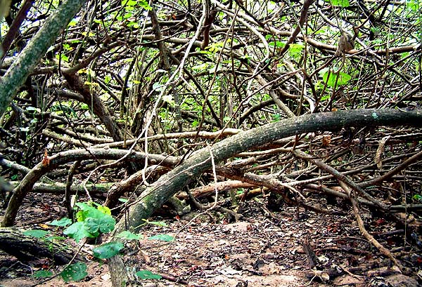
"Near the two streams that border the village—Dogas Stream and Mames Stream—are wetlands areas. On both sides of the main thoroughfare going south are unique habitats for wildlife that use wetlands. And going up north past Dogas Stream, before you get to San Roque, the borderline between Matansa and Achugao is where the other wetlands are, again on both side of the main thoroughfare, out to about Hotel Nikko. “We call wetlands sisonyan in Chamorro. It means ‘soft’ and if you step on the earth in that area, your feet will go down in the mud. That’s what sisonyan means. I don’t remember a Carolinian name. "Now, these wetlands were not used right after the war. They were used during the Japanese time. They were planting wetland taros. They were growing tilapia.”
|
|
|
“In those days, people used them to plant taro,” Rosa Castro recalls. “The elephant-ear taro, and other countries’ taro. But the Japanese used them to raise rice. The phragmites plants there didn’t exist there before, because people were farming. There was a rice plantation, and the taro and other wetland plants were there. But today we just let it go and nature takes its course again.” “The Chamorro actually planted a lot of taro," Ben adds. "The Carolinians probably planted taro and tapioca, but not a whole lot, because it’s really actually very dirty. You go in there and you come out all muddy faced. And there is what we call kankong. Some of the people may call it ‘watercress’ and it’s the same family. Kankong is an excellent vegetable. You don’t have to tend them – they are like hydroponic plants, they grow in the water.”
|
|
|
|
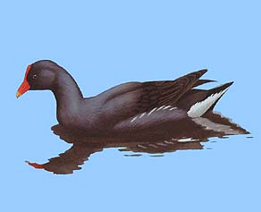
“The kankong is going extinct, I think. I’ve not seen a lot of it except for two places where they do what’s called ‘wetland mitigation.’ Somebody wanted to use these wetlands, and by Federal Law, you have to create new wetlands the same size or twice as big as the wetland you are going to use. And they’ve done two wetland mitigations, south of Mames and between Kannat Amot and south of Mames. “These wetlands are supposed to enhance the moorhen, an endangered species. This is a bird that frequents swampy land. We think they’re native birds; we know there is the same moorhen in Guam, in Rota, in Tinian and here on Saipan. Where there is wetland, you will find moorhens. But on the islands up north, even Pagan that has two inland bodies of water, we have not seen moorhens there.”
|
|
|
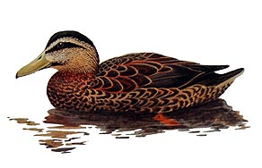
The wetlands were also home to the now-extinct Marianas Mallard. "It’s gone,” Ben says. “although there are other mallards that are coming here. Some people say, ‘No, those are the mallards that we had before.’ "The only way to tell a Marianas mallard from the migrant mallards that are coming on this Pacific flight path is that if they nest here and they produce their young, then we call them the Marianas Mallard. If they don’t stay, if they take off and go to Australia or some place else, then they are not Marianas Mallards. They are just mallards that are passing through.”
|
|
|
|
|
“There is a distinct area from the wetland to the beach side. There is a very large dry land section where the wetland doesn’t actually drain. It fills during very heavy rain and inundates the dry land, but in a day or two it subsides and there is no more water suspended there. I’m sure what’s happening is it goes down into the wetland area and it filters underground out into the ocean, so it bypasses that dry land. "But there is a very distinct area that the wetland doesn’t occupy, and it’s where the land crabs are. Land crabs are traditional food for both Chamorro and Carolinian. I’ve seen more Carolinians hunt for crabs than Chamorro. And Chamorros – like I said before, they are upland, they farm, they grow all kinds of crops, and they barter with the Carolinians for fish, maybe crabs also."
|
||
|
|
||
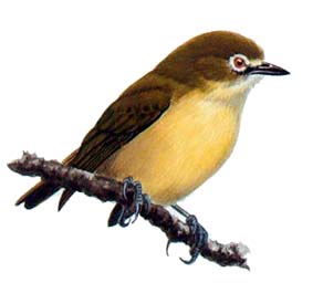
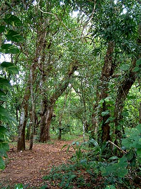
“The smaller birds, like the bridled white eye, are near shore and up in that zone with the mango trees and avocados. The Marianas starlings are also found mostly in those areas, because they like to nest in large trees and in big holes in dead trees, or they find some dead spot and they will hollow it out. The Marianas fruit dove, they really have no distinct zonation. They go up, and they go down to near the shore. Right at my house we’ve got quite a few of Marianas fruit doves.” “As you move up, you see that the vegetation climaxes as you move further inland. First there are now larger trees – mango trees. There is a distinct area just below the slope where the mangoes are growing, the breadfruits are growing, and the avocados. This is the zone where most of the water would have been brought down first, and they would have tapped that resource."
|
|
|
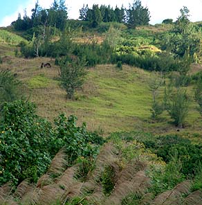
“And then up the hill we get into the zone of the sword grass, together with the Australian Pine. Of course, along the beach, you’ll find Australian pine. Not a whole lot of other trees would take to that ‘barren’ land. The Australian Pines are actually introduced here and they grow extremely well. “When you see sword grass, it indicates that the land has been devoid of topsoil. So they are very hearty plants. We think the soils are probably still very thin, and probably clay. Most of the topsoils are washed down, and only the hardiest of the hardy plants will enjoy growing on the clay area. "So we probably have a few zones, one in the lower land where most of the topsoils are, and then you get into the upper land where you find a lot of clay, and then further up, nothing but limestone.”
|
“Further north, on the hillside, you’ll find the native trees. Those are distinct populations of trees, because they weren’t really hit hard by the war. This particular area above Tanapag was heavily farmed by the Japanese and Koreans and Okinawans, and so it has not actually climaxed through to the original native trees. “Maybe after the war native trees just couldn’t come back, and so that sword grass took over. It will probably climax at a later time with taller trees. Right now there’s a lot of Australian pines up on denuded grounds, and eventually more native trees will come back, but it’s taking so long. It’s over 50 years since the War, and some of these grassland areas up here have not shown any tendency to climax into other plant species. We’re hoping that with all the luck that we have, that this will climax to a native forest.”
|
|
|
|
|
|
“So far, that’s the climax of the plants that we have here. Of course those weren’t here during the War. The United States soldiers burned every tree down so that they could find the Japanese soldiers. Terrible way to go. They should do it in their own back yard, not in our yard."
|
||
|
|
||
These areas exist in an intimate web of relationship with other environmental forces. Go next to the winds page.
|
||
|
|
||
|
|
|
|
|
|

|
| Tanapag Home | Map Library | Site Map | Pacific Worlds Home |
|
|
|
|

|
 |
|
|
|||
| Copyright 2003 Pacific Worlds & Associates • Usage Policy • Webmaster |
|||