 |
 |
 |
|||||
|
|
|
|
|
|
|
|
|
|
|
|||||||
|
|||||||
|
The restored taro terraces or lo‘i at Limahuli Gardens. |
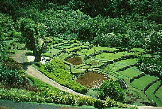
The lower portions of Limahuli Valley, and the short slopes of Manoa Valley, were laced with terraces for using water to grow taro. Over the last century, as populations dwindled and modes of production changed, much of this agricultural land fell into disuse. But that it once supported a flourishing and important community is certain. Here is a discussion by E.S. Craighill Handy (1972: 418-419), who studied Hawaiian agriculture intimately, regarding Ha‘ena: "There are extensive areas of small wet-taro terraces in the lower part of Limahuli Valley, and the sloping and flat lands east and west of Limahuli stream between the sand dunes and the mountain sides were terraced and watered by ditches from that stream. In another small valley, Manoa, there were also many terraces. A few hundred yards east of Limahuli stream there is a swampy area where taro was grown in a unique way that was practiced only here and in the marshes of Mana and Wai‘eli, west of Kekaha. Swamp earth was piled up one rafts that were partly submerged, probably resting on the soft bottom of the swamp, and in the earth on these rafts the taro was planted.
|
||
|
|
||
"On the sandy areas along the coastal plain sweet potatoes [‘uala] were grown. Formerly many varieties of banana [mai‘a] were planted in Limahuli and Manoa Valleys, as well as many kinds of sugar cane [ko] and several varieties of ‘awa." Handy also remarks that while cultivation of coconut [niu] was limited in Hawai‘i due to its northerly latitude, on Kaua‘i "the favored places" included Ha‘ena and Hanalei.
|
||
|
|
||
This quite possibly may be the famous Hala o Mapuana.
|
The puhala, or pandanus tree, was planted from seed near houses, though it also grew almost everywhere along coasts and in lower valleys. Handy (1971: 193-4) states that at Ha‘ena, there was a tree named "Ka Hala o Mapuana" that was famous in meles, with a "deep reddish 'key.'" He reports that Mary Kawena Pukui saw it in 1936 and noted that it appeared to be dying. Describing the area in the 1930's, Handy remarked that "Extensive areas of small terraces (lo‘i), now abandoned and used only for pasture, fill the lower part of Limahuli Valley. The sloping and flat lands east and west of Limahuli Stream between the sand dunes and the mountain sides were developed in terraces, irrigated by ditches from Limahuli Stream. About a dozen of these terraces are now under cultivation in taro. The rest are used as pasture or abandoned under brush and grass...."
|
||
|
|
||
|
|
"There were many small terraces," Handy wrote, "and on the flatland immediately adjacent to the hills. All this land is now unused." While Limahuli Valley has been restored at least in part, and the Near-shore area is undergoing a slow but steady transformation back towards being productive, Manoa Valley has returned to the forest. Chipper says, "As you splash Manoa stream as you go by Maniniholo cave, if you go up Manoa valley, it's a very shallow valley. There is a lo'i complex that was developed within that valley, and also, there's a luakini heiau up in there. It was an important cultural area, but a relatively small one within the ahupua‘a of Ha‘ena. It's hard to see anything there now, because the awapuhi and stuff is all growing, and its covered everything. You go back there in the winter, and a lot of the ground cover has died back, and you can see the wall structures a lot better."
|
||
|
|
||
One could say that Manoa Valley returned to its role of providing food in the 1960s. When an area nearby adjacent to what is now Ha‘ena State Park was taken over by hippies in what became known as "Taylor Camp," Manoa Valley was known to the inhabitants as "Mango Valley." Today mango trees dominate the forest of Manoa. But underneath these transformed landscapes there remains another landscape of stories and place names, the footprints of the old ones.
|
||
|
|
||
| |
| |
|
|
 |
| Ha'ena Home | Map Library | Site Map | Hawaiian Islands Home | Pacific Worlds Home |
|
|
|
|
|

|
|||
| Copyright 2001 Pacific Worlds & Associates • Usage Policy • Webmaster |
|||