 |
 |
 |
|||||
|
|
|
|
|
|
|
|
|
| Orientation to Tanapag |
|
|
|

"Tanapag village extends all the way down to the harbor. When we look at the map we see 'Tanapag Harbor,' but people living in that area above the harbor refer to their home as Puerto Rico, so we don’t have that land designated as Tanapag," Ben says. While legal boundaries of Saipan's villages may be unclear, the conceptual boundaries can be drawn.
|
||
|
|
||
The Tanapag area traditionally was fairly large. But following the Second World War, the U.S. Navy built a large facility that took up much of the Southern portion of the Tanapag area. This part of Tanapag is still referred to as "Lower Base." Ben explains, "Hardly anybody lives down here in what’s Lower Base now. It’s all garment factories and government offices. We still have the Public Works Divisions down in that Lower Base. The power plant is still there, the main power plant, and companies like the water company, the paint company, the glass company, the company that fabricates parts, and the bus company are down there. Now the transfer station for our garbage is down in those Lower Base areas."
|
|
|
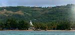
"Puerto Rico is the port of Saipan. It has a large opening for big vessels. But it's not as big as some military prepositioning ships that we often see anchored out there. They should be in the dock area, but they’re so big that their draft is too deep for the harbor channel, which is only about 30 to 40 feet. "Puerto Rico is a new name. During the Japanese time it wasn’t called Puerto Rico, which is Spanish, Puerto means the ‘way in’ and Rico means ‘rich,’ so it’s a rich harbor. That’s the significance of Puerto Rico."
|
|
|
|


"Achugao is the name of a village, and this stream, Saddok Dogas, creates the boundary between Achugao and Tanapag. Achugao is one of the first areas where the Chamorros landed when they migrated to Saipan. That has been documented. "
|
||
| |
||
|

"There are two bridges that bound the village proper. Those are over two dry creeks; the water would be running when it rains, so they constructed bridges. They’re not elaborate bridges, but you would recognize them when you pass through the village. "I can still remember that there weren’t that many houses in those days. There were quite a few people in this village, but we cooperate very closely. If somebody was to build a house, all the villagers would come and help put up a house for an individual or a family. And in about five or six days this house would be livable."
|
||
| |
||


"Tanapag is a culturally oriented village, and I think we are living very peacefully here," Ben concludes. "When I was growing up, we considered ourselves to be a community that centers our livelihood primarily on two things.The majority of the people were actually fisherman, and they still practice traditional fishing methods. The other section of the population were farmers, so there was an ongoing barter, trade back and forth between the farmers and the fisherman. And so we had a very lively little community that traded amongst ourselves."
|
||
|
|
||
|
We will explore Tanapag more closely. But first, we need to get there.
|
||
|
|
||
|
|
|
|
|
|

|
| Tanapag Home | Map Library | Site Map | Pacific Worlds Home |
|
|
|
|

|
 |
|
|
|||
| Copyright 2003 Pacific Worlds & Associates • Usage Policy • Webmaster |
|||