 |
 |
 |
 |
||||
|
|
|
|
|
|
|
|
|
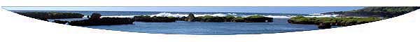
| Orientation to Inarajan | |
|
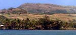
The Municipality of Inarajan.
|
|
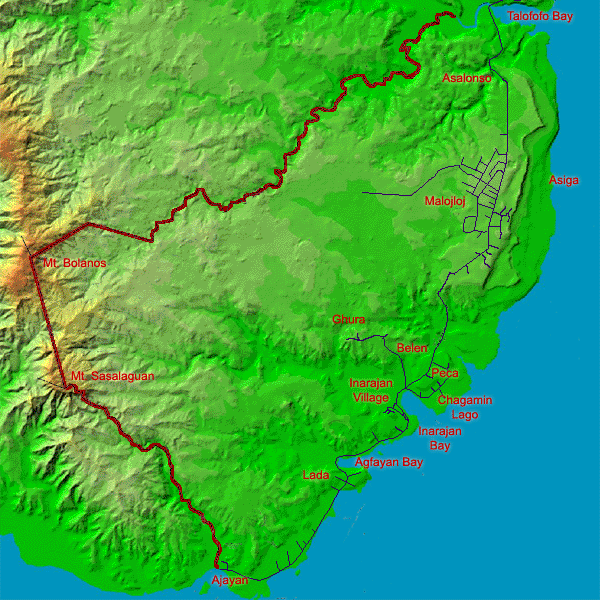
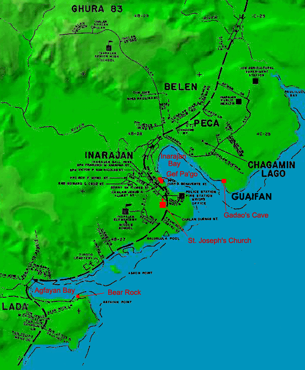
“Inarajan is broken down in different sections” Therese explains. “Malojloj is a large portion of Inarajan. People ask, 'Is Malojloj a separate village?' Well, no, it’s getting sort of that way, but it started off as a very small farming community. And then a lot of people decided they wanted to build houses, and raise their families up there. So we have a lot of families living up there, setting up their foundation and just growing. And so Malojloj in itself is a growing, big part of Inarajan." “I think of Inarajan as the entire district,” says Bill. “For me, it really bothers me when somebody says that Malojloj is a village. I remember I was invited to represent the mayor of the municipality and somebody stood up and said, 'This is the village of Malojloj' and I stood up and I made that correction. This is not a village. It is part of the municipality just like the area that I’m staying at right now, which is called Belen."
|
||
|
|
||
|
Areas within the village of Inarajan.
|
|
“We have other sections within the village of Inarajan,” Therese tells us. “There’s Lada, Peca, and then Chagamin Lago is right across the bay. Belen and Tinaga are just various sections. I’ve learned these names as I grew up from my grandparents and my mom and dad. So I know if you say a family is Crisostomo, someone will ask, ‘Okay, which Crisostomo are you -- the Crisostomo from Lada, or the Crisostomo from Malojloj?’, because there is a Crisostomo from Malojloj, and we’re related. It’s just that we live different parts of the village. Meno — there are Menos in Belen, and there are Menos in Malojloj. So often times you need to know the family name. My mother’s father is known as Shorty, only because of his stature. So when people say, ‘Are you the granddaughter of Shorty?’ I know exactly who they’re talking about. Often times it’s not just the area where you live but it’s also the family you come from.”
|
||
|
|
||
|
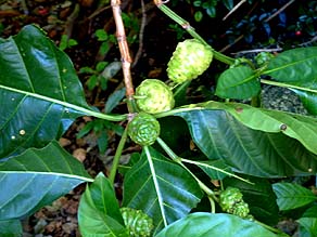
Lada, known by the Hawaiian name Noni.
|
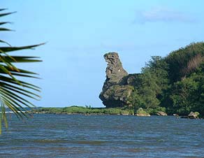
“Lada is where I live and, the reason they call it Lada is because of the trees. In Hawaiian they’re called noni trees. Well, they are in abundance down in that area. A lot of people drink it for medicinal purposes. I guess when they found that noni was pretty popular, and that it’s similar to what we have here, they started boiling and drinking it, and one thing led to another and they found a use for the tree. My father has a tree behind his house, which is falling down with fruits. So that’s why they call it Lada and it’s down near Bear Rock.”
|
|
“Bear Rock is a natural formation of the rock, the wear and tear of the rock. Somebody said there was a story of a bear, but I think it was just a made-up story, I don’t think it is a legend. Because it’s not part of our legend, it’s just a formation of a rock, a natural formation that happens through nature as the years and the wear and so on. "I think when you look at it in one direction it doesn’t look like a bear then, you look at it in the other direction and it does look like a bear.”
|
|
|
|
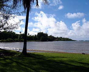
"Gue’ha is a word in Chamorro where you take something and fan yourself,“ Bill explains. "And Guaifon is a beach area. My father owned a property there called Guaifon. I remember the sandy area there where we were, and it was always a very cool area. By 7:00 pm in that area, you need something to cover yourself. I imagine that was the reason why it was given that name Guaifon. "We used to also plant there with my parents, the sweet potatoes. My parents would plant acres of sweet potatoes, and during harvest time we would invite a lot of people over there just to harvest the sweet potatoes. We couldn’t really sell them, who could we sell it to? So people would come during harvest time.”
|
|
|
|
|
"In my area, which is going up to the middle school, it’s called Se’se’, and when you really look at it, Se’se’ is 'knife,' and the way the property of this is, there’s an area there where there’s a stream. In summer it gives that figure of a knife and that’s why it’s called Se’se’. And so that area is called Se’se’. "Basically the reason for these names were because of a certain situation, not particularly a name of a person, but because of the way of the land is geographically, that’s how it received it’s name.”
|
||
|
|
||
|
We will explore many more areas of Inarajan municipality later, when Rufo Lujan gives us a tour down the coast and orients us to different Areas in The Land chapter. But first, we need to get there.
|
||
|
|
||
|
|
|
|
|
|

|
| Inarajan Home | Map Library | Site Map | Pacific Worlds Home |
|
|
|
|
 |
 |
|
|
|||
| Copyright 2003 Pacific Worlds & Associates • Usage Policy • Webmaster |
|||