 |
 |
 |
|||||
|
|
|
|
|
|
|
|
|
|
|
|||||||
|
|
|
|
|
|

| “The streams ran when there was rain,” ‘Ilima states. “It’s still the same today. Sometimes, for several years there is no water. As a matter of fact even with this big rain that we had, not all the streams had water. “I’ve seen several times where every stream had water. It would be so exciting for our kids, because they never saw that, you know. So we’re driving and say, ‘Oh, water!’ and we’d just kind of slow down and everybody’d see the water. There’s quite a few streams, and I’m not sure if all of them have names either.”
|
||
|
|
||
“If I remember counting, I would say there is probably thirteen streams. Probably thirteen of them, on the whole Kohala Mountain Road. When there is lots of rain, I think I counted 13 at one time that had water. And you can more or less tell that it’s a stream because you see rocks and you see kind of an indentation, and then when it rained, there was lots of water. “What I’ve noticed is that when some important person dies, there is rain and the streams will get full. And I’ve seen this several times. Every stream, every stream has water. And you can tell when the streams have water because, Honokoa Bridge coming to Kohala, the water is all muddy. That’s the biggest stream—it goes right thorough and under Honokoa bridge.”
|
|
|
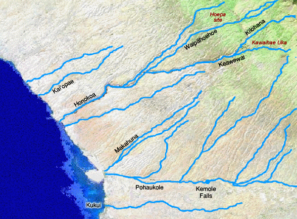
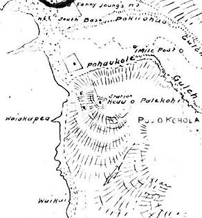
"Honokoa is down here," Papa explains. "Mauka is Keawewai. That’s Keawewai coming down, then it meets Honokoa. You get one more kahawai coming from Kawaihae area down, so there’s a Y, and it runs down into Honokoa. And as it gets down, Honokoa gets deeper and deeper until it’s down at sea level when you get down to this elevation. "The name of the kahawai that comes into Pelekane is Pohaukole. That one runs over here and goes way up about 7 miles. It comes off the one main kahawai that runs through Waimea. One is where the waterfall is back there. And then on this side of the HPA school, there’s another one comes out and crosses the road, then it meets down by the Waiaka. Comes down together, and flows down. "But then you go part way, get different names."
|
| |
|

|
"You know, all these streams used to run freely before, when they didn’t disturb the forest area. But when the plantation came in, pau eh? They want all the water, so they go up into the forest and they see what they can get, and they just cut it off. That’s why, only when you have heavy storms and stuff like that, when have heavy rain, then the streams run, but on normal days where you have the regular rain in the forest there, so all that water always go down the other direction because they blocked there, for flowing this way, you see. So that’s the whole trouble, that’s where all these kahawai you see coming, they are all dry."
|
||
| |
||
“The Kehena ditch and the Kohala ditch trail system, which are on the North side, mostly take water from the streams that are running down toward the north slope of Kohala,” Sam explains. “Many of the streams coming down Kawaihae would have been intermittent streams. That is, they wouldn’t have run all year long. "I have no doubt that in the days when there was more solid forest all the way down, that many of those streams would have reached the ocean way more often than they do now. And that, between denudation of the land and extraction of water, very rarely do any of those streams run all the way down to the sea anymore."
|
|
|
“Even within the lifetimes of people who are alive now, they talk about how in their childhood it used to be a lot rainier and the schools would be closed more. You never hear about that, schools being closed because of rain nowadays. So, who knows if we aren’t seeing major slow cycles of wet and dry. "But where you have forest, it’s a lot wetter even during the dry times, so the loss of the forest along the whole half of the Kohala mountains leading down into Kawaihae probably had a lot to do with the waters not running anymore.”
|
|
|
|
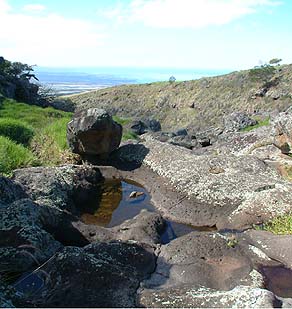
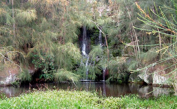
A waterfall and pool on the Waipahoehoe stream, above Hoepa. The foliage is introduced ironwoods.
|
“It was said of Keliimaikai that whatever he dedicated became very kapu," wrote John Papa I‘i, speaking of one of Kamehameha's chiefs. "If it was a bathing pool, it became so kapu that men were not allowed to bathe there with malos [loinclothes] on. Because of this rule, a bathing pool in the upland of Kawaihae was called Keliialaalahoolaawai [The chief who roused to dedicate the water " (Ii 1959: 59). The location of this upland pool is not known.
|
||
|
|
||
Kawaihae Uka former resident Hannah Awa‘a told Charles Langlas that water was brought from the Waipahoehoe stream over to the gully that the house lots were on in order to water the gardens. In her childhood there was a pipe laid above the church there to bring the water, but she thought earlier there had been a ditch in that location (Langlas 1994: 19 footnote). “In Mrs. Aveiro’s day," Langlas adds, "the Waipahoehoe ran much of the time, but only when the flow was high was there enough water to come through the auwai system down at Horepa. In dry periods there was only water left in the pools. They used the stream not only for the irrigation but also for drinking and bathing” (Langlas 1994: 20).
|
|
|
“Also in Kawaihae was a kapu bathing pool called Alawai,” I‘i wrote (1959: 59). While this site has not been identified by local residents, a bathing pool in Kawaihae was described by William Ellis in the 1820s: “Between seven and eight in the morning, we walked to the warm springs, a short distance to the southward of the large heiaus, and enjoyed a most refreshing bathe. These springs rise on the beach a little below high-water mark, of course they are overflowed by every tide; but at low tide, the warm water bubbles upthrough the sand, fills a small kind of cistern made with stones piled close together on the side towards the sea, and affords a very agreeable bathing place. The water is comfortably warm, and is probably impregnated with sulpher: various medicinal qualities are ascribed to it by those who have used it,” (Ellis 1969: 397).
|
| |
|
“Waiakape‘a is spring water out in the ocean,” Papa says, “right below the heiau. It’s still there, still bubbling up. We never went out there to collect that water, because we had enough water. But we knew about it. If we ever ran out of water, we might have done that. Waiakape‘a is just like a fan: blows up and goes down.” “Eddie La‘au [senior] pointed out a place called Waiakape‘a,” Marion writes, “adjacent to Pelekane and about 20 feet from the shore, where the water wells up from under the surface. It is said to have once been warm and to have had some healing qualities that attracted many people to bathe there, in spite of its proximity to Hale-o-Kapuni and its associates” (Kelly 1974: 28, footnote).
|
|
|
“We had fresh water, piped running water,” Lani recalls. “They had a meter there, the county, they put the water in. The first time we had to pay Parker Ranch for it, then after a while the county got involved in it, running water. There was a meter in front of our yard, and they would come every month and check your meter, how much water you used.” “The water comes down from Waimea halfway from the powerhouse," Mel says. "From there the water pipe goes down to Kawaihae. It is located above ground, so all the water coming down the pipe to Kawaihae is warm. Today the water in Kawaihae is better. There's an ice house, and a refrigerator in most homes. If there is no ice, then it’s fresh warm water." “There was piped water,” ‘Ilima concurs, “but you never needed a water heater in Kawaihae. And you still don’t, because a lot of the pipe is above ground, so the water was always warm. It was never refreshing. Never. It was always warm.”
|
|
|
|
The close relationship of water to food leads us to look at planting in Kawaihae.
|
||
|
|
||
|
|
|
|
|
|

|
| Kawaihae Home | Map Library | Site Map | Hawaiian Islands Home | Pacific Worlds Home |
|
|
|
|
|
|
|


|
|
|||
| Copyright 2006 Pacific Worlds & Associates • Usage Policy • Webmaster |
|||