 |
 |
 |
|||||
|
|
|
|
|
|
|
|
|
|
|
|||||||
|
|
|
|
|
||
"We know that the people of old ranged across the landscape up into the high elevations of Mauna Kea," Hannah states. "I don’t have a strong sense of permanent habitation, up in the cold of Waimea, but all of those gulches along the South Kohala Coast line, if we go and look amongst the kiawe, we’ll find evidence of habitation. Whether it was permanent habitation, or occasional according to what fish were running, according to what climatic conditions were, I cannot say. But generally, where the fishing was good and the water was available, we tended noho—we came to stay at these places."
|
||
| |
||
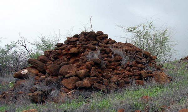
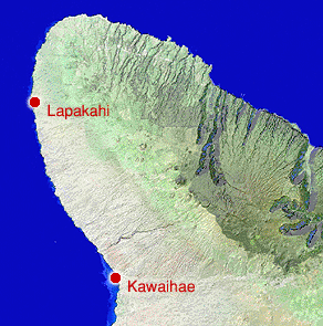
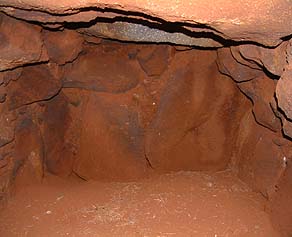
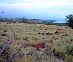
While extensive archaeological work in Kawaihae has focused on the historical-era structure of Pu‘u Kohola heiau, exploration of the more ancient habitation in this leeward Kohala area have been conducted further up the coast, at Lapakahi. At the coast of this ahupua‘a sits the remains of a small fishing village around Koai‘e inlet. Patrick Kirch (1985: 178) explains, "Inland of this coastal strip, the next 1 to 2 kilometers are relatively barren, largely because this lowland zone has insufficient rainfall and poor soil development, making it unsuitable for agriculture. Between about 2 and 4 kilometers inland, however, is an intensive zone of agricultural features dominated by a reticulate grid of field boundaries. Interspersed among these fields are minor agricultural features, as well as residential sites, largely C-shaped shelters of various forms and dimensions."
|
|
|
Various archaeologists have proposed historical sequences for this area. Kirch reports that the first use of the area appears to have been about 1300 A.D. This focused on the marine resources, with the small village on the coast. Around 1450-1500, the settlement expanded into the upland agricultural zone, with the initial development of dryland field systems. The settlement continued to expand along the coast from this initial hamlet at Koai‘e during the 16th and 17th centuries, and the upland field systems similarly intensified. When Archibald Menzies visited the Lapakahi area in 1793 he remarked that this area "bears every appearance of industrious cultivation by the number of small fields into which it is laid out" (cited in Kirch 1978: 230).
|
|
|
|
“Kohala is a pretty hospitable mountain,” Hannah adds. “It’s only 5,000-plus feet high. So it’s possible to get up into those forest resources. Time depth of occupation again would vary on both social conditions and the physical conditions. I’m imagining the gulches occasionally running in an uncontrollable fashion, and water being destructive as well as a fetcher for people to come and noho at those places. "So I feel that Kawaihae had a number of neighbors. I don’t know in terms of how townships are neighboring to one another. I’m thinking more of places where resources could allow that accumulation of either single families, or a few family cohorts."
|
|
|
"Well, you know, you look in the old study and you study the dry land farming," Billy says, "there’s evidences of certain amount of irrigation. I imagine we had more, more water back then in the, those plains going down. Even in South Kohala there’s evidences of, below Kahua and all that area where they did certain amount of irrigated farming way back then. "And Hawaiians were smart with using mulch and things of that nature so that whatever the moisture they would get, they would maintain it by keeping that on. I’d say the bulk of the populace lived maybe from Hawai‘i Preparatory Academy [just below Waimea] down. There are more evidences of population in that area." "We have from the accounts of the heiau above Hawai‘i Preparatory Academy," Hannah adds, "which was used to regulate water coming out of the Kohala mountain watershed."
|
| |
|
|
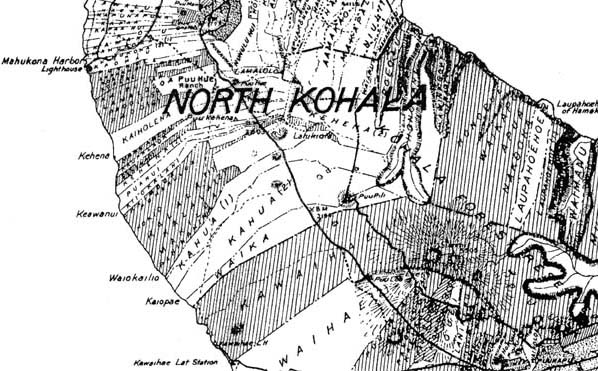
A look at the map shows that going up the coast towards Lapakahi, there are many, very narrow ahupua‘a. This would seem to indicate a high population. Yet today, this dry area is virtually abandoned. Sam explains: “When you think about ahupua‘a, you have to think more than just what was available on the land, and I would expect that some of the ocean resources over there would have been also really rich. It could be that those ahupua‘a were used to divide up the coastal resources, and just happened to extend all the way up into mauka because that’s what ahupua‘a do.” "Oh, yea. People lived there," Papa states. "I guess the population within that area was good. Because there’s so any ahupua‘a. But you know, you go back maybe 200 years, 300 years, it’s not like today. Different. Because the world changes. Before, everything followed the seasons. You get a lot of rain and all that, so the land is well taken care of. You get forest running down lower."
|
||
|
|
||
"So that’s why the people always have the mauka-makai connection. Forest is too wet. So just like the middle way, there they do their farming. Then when they do all that, then they go down to the ocean side and they do their fishing. So the rotation of the season, that’s how they go with that. "You got to be on timing. No matter where you go in the world, you gotta be timing when you doing things, you know. Especially if you’re a farmer. You cannot plant early, you cannot plant late, but you just have to be on time. When you do things on time, everything comes out perfect. So they go by that law, they live by that law. That’s the way they survive."
|
|
|
"If you go along the coastline, you see areas where you can tell that people used to live there. Because they depended on fresh water coming from above. But then things change today. So much things going on and they put so much things in the atmosphere and there’s all kind of stuff up there. So it kind of change even the air we breathe, the ocean water we swim in or fish in. "So a lot of changes. The water that runs down from the forest before, it was nice and clean, no problem there. But today, you don’t know. There are wild animals and stuff like that, and it is putting so much disease and contamination in the streams. You have to live with it today. But in the past it was different."
|
|
|
|
"Because of a lot of changes, most of those people moved out, they moved away. There’s a lot of people we know that were born in those areas. But when they started cutting those resources off, bringing in animals that went wild in the upper land there, you cannot depend on what it was before. So with all of that, people gradually moved out of there. That’s why each area has certain name, because it has a meaning to it. That’s why they named it. But now, nobody."
|
||
|
|
||
|
|
|
|
|
|

|
| Kawaihae Home | Map Library | Site Map | Hawaiian Islands Home | Pacific Worlds Home |
|
|
|
|
|
|
|


|
|
|||
| Copyright 2006 Pacific Worlds & Associates • Usage Policy • Webmaster |
|||